Geotechnical Slope Analysis 2nd Edition: Principles, Methods, Stability Assessment, and Real-World Applications
Introduction
Geotechnical slope analysis is a fundamental part of civil and geotechnical engineering. Whenever engineers construct a road cut, railway embankment, retaining system, mine excavation, landfill, dam, or hillside development, they must understand how the ground may behave under natural and changing conditions. 🏔️🦺
A slope can appear perfectly stable for decades and then experience movement after heavy rainfall, excavation, erosion, groundwater changes, earthquakes, or construction activities. The purpose of slope analysis is therefore not simply to determine whether a slope is standing today. It is to evaluate how safely the soil or rock mass can resist forces that may cause movement or failure.


Modern slope analysis combines field investigation, geological interpretation, soil and rock mechanics, groundwater assessment, numerical modeling, and engineering judgment. Depending on the project, engineers may use simplified analytical approaches, limit-equilibrium techniques, finite-element models, or specialized software.
For students, slope stability provides an excellent example of how theoretical soil mechanics becomes practical engineering. For professionals, it demonstrates why site characterization and realistic assumptions are often just as important as sophisticated calculations.
Background Theory
Why slopes become unstable
A slope remains stable when the forces resisting movement are sufficiently greater than the forces attempting to move the soil or rock mass downslope.
Several factors influence this balance:
- Soil shear strength
- Slope geometry
- Soil density and structure
- Groundwater conditions
- Surface and subsurface drainage
- External loading
- Erosion
- Excavation
- Seismic activity
- Weathering
- Geological discontinuities
- Vegetation and land use
The situation becomes more complicated because these factors can interact.
For example, rainfall may infiltrate the ground, increase pore-water pressure, reduce effective stress, soften susceptible materials, increase soil weight, and create seepage forces. A slope that was stable during dry weather can therefore become vulnerable during prolonged rainfall. 🌧️
Shear strength and effective stress
The fundamental concept behind slope stability is shear resistance.
Soil particles interact through friction and, depending on the material, cohesion or bonding. The available shear resistance is influenced by effective stress rather than simply by the total weight of the soil.
Groundwater plays a particularly important role because increasing pore-water pressure can reduce the effective stress between soil particles.
This is one reason why drainage is frequently among the most effective slope-stabilization measures.
Typical slope failure mechanisms
Different geological and geometric conditions can produce different failure mechanisms.
Rotational failure
Rotational failure commonly occurs in relatively homogeneous soil slopes. The sliding mass follows a curved failure surface.
This mechanism is frequently considered when evaluating:
- Earth embankments
- Highway cut slopes
- Clay slopes
- Engineered fills
Translational failure
A translational failure involves movement along a relatively planar surface.
It can occur where weak soil layers, bedding planes, joints, or interfaces provide a preferential sliding path.
Wedge failure
Wedge failures are particularly important in rock slopes. Intersecting discontinuities can create a wedge-shaped block that moves outward and downward.
Rockfall
Rockfall involves individual blocks or fragments detaching from a rock face. Although the mechanism differs from large soil landslides, rockfall remains an important slope hazard near roads, railways, tunnels, and infrastructure.
Definition
What is geotechnical slope analysis?
Geotechnical slope analysis is the engineering process of evaluating the stability, deformation behavior, and potential failure mechanisms of a soil or rock slope under specified geological, groundwater, loading, and environmental conditions.
The analysis generally seeks to answer several questions:
- Is the slope stable under current conditions?
- What failure mechanism is most likely?
- Where could a potential failure surface develop?
- How will groundwater affect stability?
- What happens during construction?
- How sensitive is the slope to changes in soil properties?
- What stabilization measures are appropriate?
- How will the slope perform under unusual or extreme conditions?
Factor of safety
One of the most familiar concepts in slope engineering is the factor of safety.
It represents the relationship between the available resistance and the forces driving potential failure.
A factor of safety greater than the selected design requirement generally indicates that the calculated resistance exceeds the driving demand. However, engineers should not interpret a single numerical value as an absolute guarantee of safety.
The result depends on:
- Soil parameters
- Groundwater assumptions
- Geometry
- Loading conditions
- Failure-surface assumptions
- Model limitations
- Quality of site investigation
⚠️ Important: A sophisticated computer model cannot compensate for incorrect geological or geotechnical assumptions.
Step-by-Step Slope Analysis
Step 1: Define the engineering problem
Begin by identifying the purpose of the analysis.
Is the project:
- A new road?
- A railway embankment?
- A residential development?
- A dam?
- A mine?
- A landslide investigation?
- A temporary excavation?
- A coastal or riverbank slope?
The design objective determines the required investigation and analysis level.
Step 2: Investigate the site
A good slope analysis begins in the field—not in the software.
Typical investigations can include:
- Boreholes
- Trial pits
- Cone penetration testing
- Standard penetration testing
- Geological mapping
- Groundwater monitoring
- Laboratory testing
- Geophysical surveys
Engineers should identify soil layers, rock formations, discontinuities, groundwater levels, weathered zones, previous landslides, and evidence of existing movement.
Step 3: Establish slope geometry
Accurate geometry is essential.
Survey information should establish:
- Slope height
- Slope angle
- Crest location
- Toe location
- Benches
- Nearby structures
- Roads
- Drainage channels
- Existing cracks or scarps
Even a small difference in geometry can influence the predicted stability.
Step 4: Determine engineering properties
Representative soil and rock parameters must be established from appropriate field and laboratory information.
Important properties may include:
- Unit weight
- Shear strength
- Cohesion
- Friction angle
- Permeability
- Compressibility
- Rock strength
- Discontinuity characteristics
The selected parameters should reflect the relevant drainage condition and expected behavior.
Step 5: Assess groundwater
Groundwater is one of the most important variables in slope analysis.
Engineers may investigate:
- Water-table elevation
- Seasonal fluctuations
- Perched water
- Artesian pressure
- Seepage
- Drainage conditions
- Pore-water pressure


Step 6: Identify potential failure mechanisms
Before selecting a computational method, engineers should develop a geological and geotechnical model.
Potential mechanisms might include:
- Circular sliding
- Translational sliding
- Wedge failure
- Planar rock failure
- Toppling
- Shallow erosion
- Deep-seated landsliding
Step 7: Select the analysis method
The method should match the engineering problem.
Common approaches include:
- Limit-equilibrium analysis
- Finite-element analysis
- Finite-difference modeling
- Strength-reduction techniques
- Kinematic rock-slope analysis
- Empirical assessment
Step 8: Evaluate design conditions
The slope should be assessed under appropriate scenarios, such as:
Normal condition → Rainfall condition → Construction condition → Long-term condition → Seismic condition
The governing condition is not always the normal operating condition.
Step 9: Perform sensitivity analysis
Because geotechnical parameters contain uncertainty, engineers should test how the result changes when important variables vary.
For example:
- Lower soil strength
- Higher groundwater
- Increased surcharge
- Steeper geometry
- Reduced drainage performance
This helps identify which parameters have the greatest influence on stability.
Step 10: Develop mitigation measures
If the slope does not satisfy the required performance criteria, engineers can modify the design.
Possible measures include:
- Flattening the slope
- Removing unstable material
- Installing drainage
- Adding berms
- Constructing retaining systems
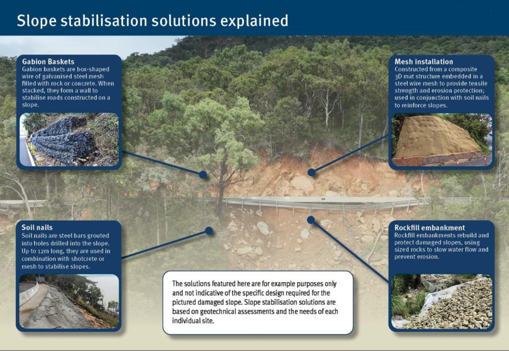
- Soil reinforcement
- Anchoring rock
- Soil nailing
- Vegetation and erosion control
- Improving weak soil
Comparison of Slope Analysis Methods
Different analytical approaches provide different levels of complexity and insight.
| Method | Typical Use | Main Advantage | Main Limitation |
|---|---|---|---|
| Ordinary limit equilibrium | Preliminary assessment | Simple and practical | Simplified assumptions |
| Bishop-type methods | Circular failures in soil | Widely applicable | Primarily suited to specific failure geometries |
| Janbu-type methods | More general sliding surfaces | Flexible | Requires careful interpretation |
| Morgenstern–Price-type analysis | Detailed stability assessment | Comprehensive force/equilibrium treatment | More computationally involved |
| Finite-element analysis | Stability and deformation | Captures stress-strain behavior | Requires quality input data |
| Strength reduction | Numerical stability assessment | Useful for complex geometry | Sensitive to model setup |
| Kinematic rock analysis | Rock slopes | Effective for discontinuity-controlled failures | Requires reliable structural mapping |
Analytical versus numerical modeling
Analytical methods are often efficient for routine design and preliminary evaluation.
Numerical methods can provide additional information about:
- Deformation
- Stress distribution
- Complex geometry
- Staged construction
- Material interaction
- Progressive failure
However, numerical sophistication should be justified by project requirements.
Diagrams and Engineering Tables
Conceptual slope stability model
A simplified conceptual model can be visualized as:
             Crest
               _________
              /         \
             /           \
            /   Potential \
           /    sliding     \
          /     surface      \
         /  . . . . . . .    \
        / .                  .\
       /_______________________\
                  Toe

        ← Resisting forces
                         ↓
                   Driving forces
The actual failure surface may differ significantly from an assumed circular or planar shape. Therefore, the geological model should guide the analytical model.
Key variables
| Variable | Influence on Stability |
|---|---|
| Slope height | Higher slopes generally increase potential driving forces |
| Slope angle | Steeper slopes usually increase instability risk |
| Soil strength | Higher strength generally improves resistance |
| Groundwater | Increased pore pressure can reduce effective stress |
| Surcharge | Additional loading can increase driving demand |
| Drainage | Effective drainage can improve stability |
| Erosion | Removal of material can weaken the slope |
| Seismic loading | Can significantly increase instability |
| Vegetation | Can reduce erosion and sometimes improve shallow stability |


Practical Examples
Example 1: Highway cut slope
Imagine a highway constructed through a clay-rich hillside.
During dry conditions, the slope appears stable. After several days of heavy rainfall, cracks appear near the crest and muddy water emerges near the toe.
An engineer may suspect:
- Increased pore-water pressure
- Reduced effective stress
- Saturation of near-surface soil
- Poor surface drainage
- A developing rotational failure
Rather than simply increasing the slope’s calculated resistance, the engineer may first improve drainage and modify the slope geometry.
Example 2: Railway embankment
A railway embankment is constructed over soft compressible soil.
The additional fill increases stress within the foundation. If construction proceeds too rapidly, excess pore-water pressure may develop.
A staged construction strategy combined with monitoring can allow the ground to consolidate progressively and improve overall performance.
Example 3: Rock excavation
A new road requires excavation through fractured rock.
Geological mapping reveals discontinuities dipping toward the road. Instead of treating the rock mass as homogeneous material, the engineer evaluates the discontinuity orientations and identifies a possible planar or wedge-type failure.
The solution may involve:
- Rock bolts
- Drainage
- Scaling
- Shotcrete
- Mesh
- Geometry modification
Real-World Applications
Transportation infrastructure
Slope analysis is essential for:
- Highways
- Railways
- Bridges
- Mountain roads
- Cut-and-cover infrastructure
Road construction frequently modifies natural terrain, making slope stability a major design consideration.
Dams and reservoirs
Earth dams and reservoir slopes require careful evaluation of:
- Rapid drawdown
- Long-term seepage
- Saturation
- Internal drainage
- Embankment behavior
Water-level changes can significantly alter slope stability.
Mining
Open-pit mines may contain extremely high slopes.
Engineers must evaluate:
- Rock structure
- Excavation stages
- Groundwater
- Blasting
- Structural discontinuities
- Progressive deformation
Monitoring is particularly important because conditions can change as excavation advances.
Urban development
Hillside construction can alter natural drainage and add building loads near slope crests.
Geotechnical slope analysis helps determine suitable:
- Building locations
- Cut-and-fill arrangements
- Retaining structures
- Drainage systems
- Construction sequences
Landslide risk management
For existing landslides, engineers use slope analysis to understand:
- Current movement
- Potential reactivation
- Groundwater influence
- Failure depth
- Stabilization options
Monitoring instruments such as inclinometers, piezometers, survey points, and remote sensing can complement the analysis.
Common Mistakes
Ignoring groundwater
One of the most serious mistakes is assuming dry conditions when groundwater is actually controlling slope behavior.
💧 Better approach: Investigate groundwater and consider seasonal and extreme conditions.
Using inappropriate soil parameters
Laboratory values may not always represent field-scale behavior.
Engineers should consider:
- Sample disturbance
- Anisotropy
- Soil layering
- Drainage condition
- Strain level
- Long-term behavior
Assuming the failure surface
Forcing a single failure mechanism can produce misleading conclusions.
A robust assessment considers multiple plausible failure surfaces and mechanisms.
Overreliance on software
Software can calculate results quickly, but it does not know whether the geological model is realistic.
Garbage in → garbage out. 💻⚠️
Ignoring construction stages
A slope that is stable after construction may be temporarily unstable during excavation or filling.
Construction-stage analysis is therefore essential.
Treating safety factors as absolute truth
A calculated safety factor is a model result, not a direct measurement of reality.
Engineering judgment remains essential.
Challenges and Solutions
| Challenge | Engineering Solution |
|---|---|
| Uncertain soil properties | Additional investigation and sensitivity analysis |
| Variable groundwater | Monitoring and drainage design |
| Complex geology | Geological mapping and advanced modeling |
| Limited site access | Combine field data with geophysical investigation |
| Heavy rainfall | Surface and subsurface drainage |
| Seismic hazards | Dynamic or pseudo-static assessment as appropriate |
| Existing movement | Instrumentation and back-analysis |
| Construction uncertainty | Staged analysis and observational methods |
Managing uncertainty
Geotechnical engineering rarely provides perfect information.
Instead of pretending uncertainty does not exist, engineers should identify it and manage it.
This may involve:
- Conservative parameters
- Additional testing
- Instrumentation
- Sensitivity studies
- Monitoring
- Trigger-action plans
- Construction hold points
Case Study
Conceptual highway slope rehabilitation
Consider a highway passing through a mountainous region in Europe.
A cut slope begins developing tension cracks after an unusually wet season. Small movements are observed near the crest, while seepage appears at the lower section.
Initial investigation
Engineers perform:
- Topographic surveying
- Borehole investigation
- Groundwater monitoring
- Laboratory testing
- Geological mapping
The investigation identifies a weathered soil layer over stronger material and a groundwater pathway through the slope.
Analysis
Several potential failure mechanisms are evaluated.
The assessment indicates that groundwater is an important contributor to instability. The analysis also shows that simply placing additional material at the toe would not address the underlying water-pressure problem.
Engineering solution
The rehabilitation strategy combines:
- Improved surface drainage
- Subsurface drainage
- Local slope regrading
- Toe support
- Erosion protection
- Instrumentation
Monitoring
After construction, engineers monitor:
- Ground movement
- Groundwater levels
- Surface cracks
- Drainage performance
The case demonstrates an important principle:
Slope stabilization is often most effective when the underlying cause of instability is addressed rather than simply treating the visible symptoms.
Essential Tips for Engineers and Students
Build the geological model first 🧭
Do not start with software.
Start by asking:
What materials exist? Where are they located? How are they behaving?
Treat groundwater as a primary design variable 💧
Water should not be an afterthought.
Use multiple scenarios
At minimum, consider the relevant:
- Existing condition
- Construction condition
- Long-term condition
- Rainfall condition
- Seismic condition
Perform sensitivity analysis
Determine which parameters actually control the result.
Match the method to the problem
A simple problem does not automatically require an extremely complex numerical model.
Validate the model
Compare analytical predictions with:
- Field observations
- Instrumentation
- Historical movement
- Geological evidence
Communicate uncertainty
Professional geotechnical reports should clearly explain assumptions, limitations, and uncertainties.
Think beyond the factor of safety
Slope performance also includes:
- Deformation
- Cracking
- Drainage
- Erosion
- Serviceability
- Maintenance
- Long-term deterioration
FAQs
What is the main purpose of geotechnical slope analysis?
Its main purpose is to evaluate whether a soil or rock slope can safely resist potential failure under relevant loading, groundwater, geological, construction, and environmental conditions.
Why is groundwater important in slope stability?
Groundwater can increase pore-water pressure and reduce effective stress. It can also increase soil weight and create seepage forces, potentially reducing slope stability.
What is the factor of safety in slope analysis?
The factor of safety expresses the relationship between available resistance and driving forces for a defined failure mechanism and set of assumptions.
Is a higher slope always more dangerous?
Not necessarily. Stability depends on geometry, soil and rock properties, groundwater, geological structure, loading, and other conditions. However, increasing slope height or steepness commonly increases stability demands.
Which method is best for slope stability analysis?
There is no universal best method. Limit-equilibrium methods are widely used for many conventional designs, while numerical methods can be valuable for complex geometry, deformation, staged construction, and complicated material behavior.
Can drainage stabilize a slope?
Yes. Drainage can substantially improve stability when elevated groundwater or pore-water pressure contributes to instability. The drainage system must be appropriately designed, installed, maintained, and monitored.
Why is site investigation so important?
Slope-analysis results depend heavily on the geological and geotechnical model. If soil layers, groundwater conditions, discontinuities, or material properties are incorrectly characterized, even an advanced analysis can produce unreliable results.
Can slope failures be completely prevented?
Engineering measures can significantly reduce risk, but absolute certainty is rarely possible because geological conditions and environmental loads contain uncertainty. Good design combines investigation, analysis, mitigation, monitoring, and maintenance.
Conclusion
Geotechnical slope analysis connects soil mechanics, rock mechanics, geology, hydrology, construction engineering, and risk management into one practical engineering discipline. 🏗️🌍
The fundamental objective is straightforward: understand why a slope may move, determine how it could fail, assess the likelihood and consequences of that behavior, and develop a technically and economically appropriate solution.
The strongest slope assessments do not depend solely on sophisticated software or a single calculated factor of safety. They begin with reliable site investigation, realistic geological interpretation, appropriate soil and rock parameters, careful groundwater assessment, and an understanding of construction activities.
For students, slope stability is an excellent way to develop practical geotechnical thinking. For practicing engineers, it is a reminder that the quality of the ground model often determines the quality of the engineering decision.
Whether the project involves a highway in Canada, a railway embankment in the UK, a mining operation in Australia, an infrastructure project in the United States, or hillside development elsewhere in Europe, the same fundamental principle applies:
Understand the ground → identify the failure mechanism → analyze realistic conditions → manage uncertainty → design the right intervention. 🏔️🔍🦺
That systematic approach transforms geotechnical slope analysis from a purely computational exercise into a powerful tool for building safer, more resilient infrastructure.